August 09, 2003
Views of Farmington River from Talcott Mountain, Near King Phillip's Cave
Connecticut's traprock formations shape the course of tributaries of the ancient river. One is the Farmington River, which winds down from Massachusetts into the bottom lands to the west of the Metacomet Ridge. Part of the ridge is Talcott Mountain, a long, precipitous wooded ledge just west of Hartford.
As if searching for a way east to join the Connecticut, the Farmington flows south through New Hartford as the scenic rapids in "Satan's Kingdom" into Canton , then Collinsville and Farmington, where it turns back north, through Avon and Simsbury, then east to rumble through the Class III rapids of Tariffville Gorge. It finally slides into the Connecticut River in Windsor at the site of the first English settlement in Connecticut, then known as "The Island." The land was originally granted to Joseph Loomis in 1639 and is the present day site of the Loomis Chaffee School just north of Hartford.
We climbed the walking trail along the ridge in Talcott Mountain State Park at the high point of which stands the Heublein Tower, a 165-foot structure built in 1914.
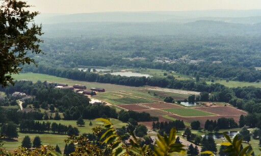
From the trail we enjoyed views of the Farmington River among the tobacco barns and cropland to the southwest, with another traprock range of hills in the far distance:
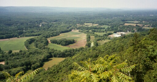
And views to the northwest, where oxbow ponds lined with rows of trees in the foreground give way to the reforested acres of Simsbury, beyond which lie the Litchfield Hills in the northwest corner of the state and the Berkshires in southwestern Massachusetts.
This was the vista from which, in 1676, the Indian leader "King Philip" is said to have watched as his warriors burned Simsbury to the ground. The large cave in the sheer west face of the mountain is known as King Philip's Cave and the ridge, of which Talcott Mountain is a part, the Metacomet Ridge. The burning of Simsbury was but one incident in the extended conflict between Indian tribes and English colonialists known as "King Philip's War," one of the bloodiest in America's history, ranging from Massachusetts Bay to Rhode Island and Connecticut. But that's another story: King Philip's War: The History and Legacy of America's Forgotten Conflict.
DougSimpson.com/river
Metacomet Ridge, The "Great Wall"
Metacomet Ridge, which shapes the flow of the Connecticut River, has been called The Great Wall. It neatly separated the commerce and transportation of Hartford and New Haven with a wall of igneous "traprock" running from Branford, CT to Northhampton, MA.
In order for New Haven to partipate in the profitable river traffic between Northhampton and the seaports on Long Island Sound, the Farmington Canal was funded and built between New Haven and Northampton during 1825 to 1835. It was plauged with problems from the start, and never proved a financial success. Hartford improved the natural waterway to Northampton with the Enfield Canal built around the shallow water at Windsor in 1829. But the development of the railroads was the final downfall of the Farmington Canal, of which a few ruins still survive along a Heritage Greenway Park.
June 15, 2003
Hobbomock's Eternal Sleep in Hamden Protects the River
Thursday turned out to be the day to be safety officer for 6 teens climbing in Sleeping Giant State Park in Hamden, CT.
Two miles of mountaintop resembling a sleeping giant give this park its name, and make it a distinguishing feature on Connecticut's skyline.

The Sleeping Giant Park Association describes the geologic formation and the native legend connecting it to the geology of the Connecticut River:
"The trap rock ridges in Connecticut began life about 170 million years ago when volcanic eruptions formed the columnar patterns of basaltic rock. This hard rock which fractures at near 90 degree angles gives the rock the name trap meaning step or stair in Swedish. In Connecticut most of these ridges run north-south, but one unique ridge six miles north of New Haven runs east-west and has the distinctive profile of a recumbent human, especially when viewed from the south. This Sleeping Giant has held a mythical quality for all who see it.
The Native Americans in the area called the Giant Hobbomock, an evil spirit who became angry at the neglect of his people and stamped his foot near the current location of Middletown causing the Connecticut River to change course. Keitan, a good spirit cast a spell on Hobomock causing him to sleep forever so that he would do no further damage."
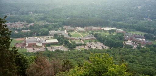
Along the climb, one finds panoramic views of Quinnipiac University.
And at the top (accessable via an easy graded fire road built by the WPA) is the 1930's era stone tower built on the high point of the Giant's "left hip" from which one can see Long Island sound and the Giant stretched out all around you. 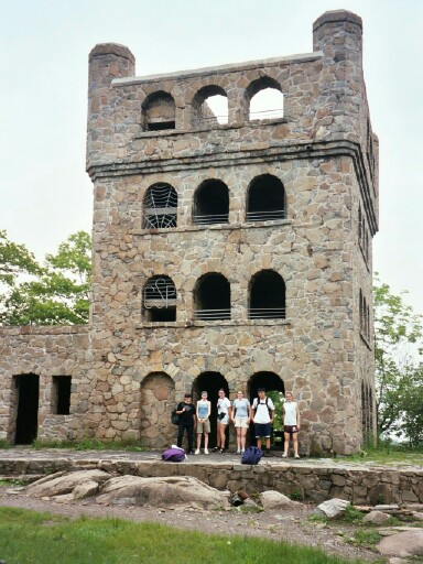
DougSimpson.com/river
June 11, 2003
In the Beginning ... Lake Hitchcock
Culture is shaped by geology and climate, and few regions have more interesting climatic and geological history than the Connecticut River Valley. What made this river a center of agriculture, industry and science dates back 15,000 years to the formation of Glacial Lake Hitchcock . Lake Hitchcock formed following the retreat of the last ice age, which had covered what is now New England with ice thousands of feet thick. Alter, "Geology of Connecticut - Glacial History" It stretched from Rocky Hill, Connecticut north some 200 miles into Vermont/New Hampshire and was 20 miles wide at points until it drained some 12,000 years ago.
This lake laid down thick sediments that not only preserved the history of dinosaurs and mastadons and the "armored mud balls" found nowhere else, but also formed the foundation for a rich agricultural and industrial future. Little, Geological History of the Connecticut River Valley
This weblog is about the cultures that grew in this well-watered valley.
DougSimpson.com/river